
A Park and an Ark
Izzy Farquharson, Diploma II, Royal College of Art, 2023
Tutors: Matthew Blunderfield & Andrea Zanderigo
The core concept of the building as a ‘park and ark’ gives reference to Ray Oldenburg’s theory of the ‘third space’. The proposal operates in two forms for two scenarios: a large internal and external landscape for recreation, leisure, food production and the exchange of knowledge and skills, offering a much-needed space of communality, while simultaneously providing a place for refuge and stability during periods of flood.
The repurposed building also performs an essential role within the town’s water infrastructure, for the ecological treatment of surface, rain and fluvial water, and brings together a variety of approaches to demonstrate how existing structures and neighbourhoods might be adapted for climate resilience. It aims to sets precedent for the town that might, eventually, reframe the town’s inhabitants’ relation to and understanding of our water systems, by changing their encounter with water.
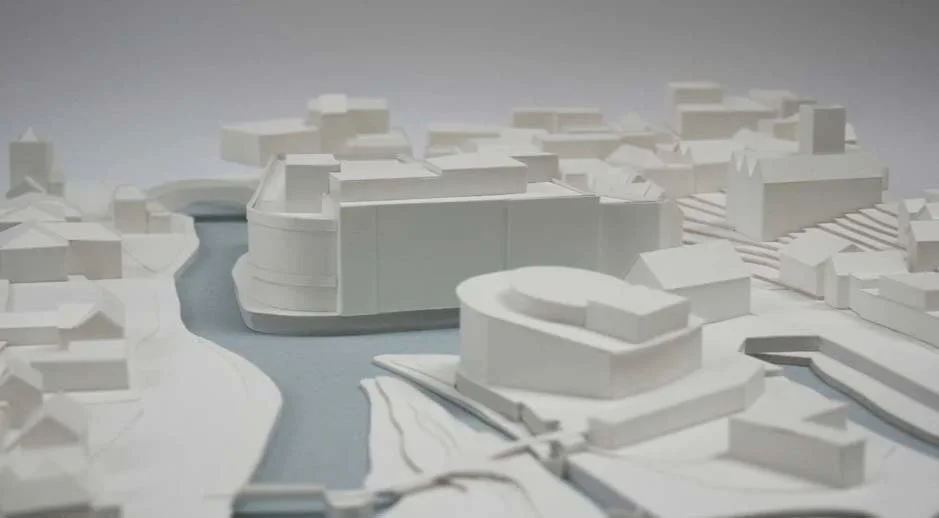
1:500 Site Model
Situated in Guildford, a town 43km southwest of central London, this former Debenhams, despite being in reasonable structural and material condition, is now scheduled for unnecessary demolition following a recently successful planning application submitted by Squire & Partners, proposing to replace it with a new, two-building mixed-use development.
Whilst the building is a fairly standard example of commercial architecture of the period, its setting is perhaps what makes it particularly beguiling. It sits independently on a wedge-shaped site on the edge of the River Wey, directly on the boundary between the urban and the pastoral.
The department store holds a prominent positioning at the end of the High Street, therefore lending itself to explore ways of how this vanishing typology can be repurposed and reimagined for an alternative, public use.
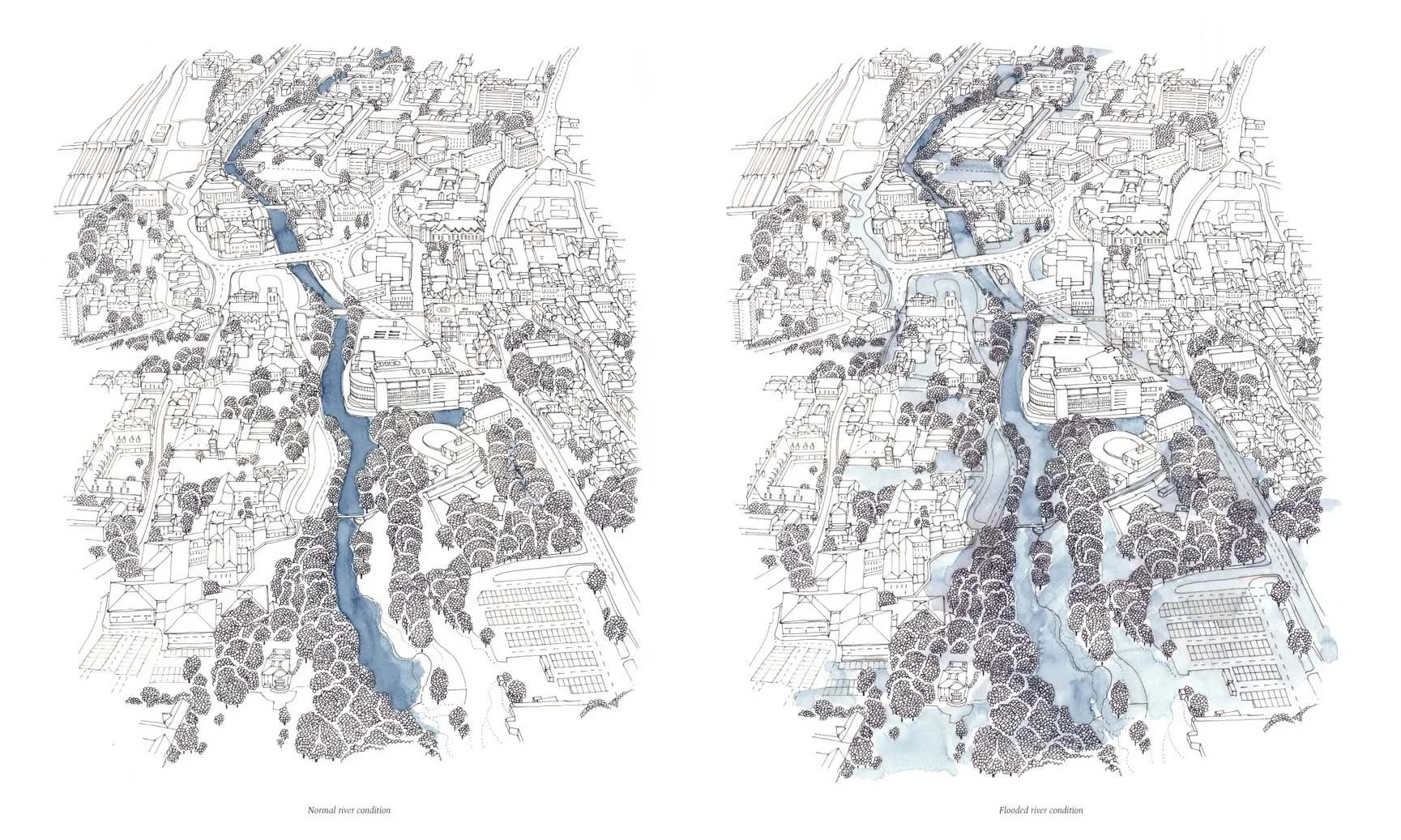
A particularly challenging, yet compelling aspect of the site is the presence of water and how frequently the town has flooded. On leaving Guildford train station, the first thing you are greeted by is a large, yet faded ‘flooding information’ board: clearly a condition which is so frequent and affecting that it demands a sign right outside the town’s central station. However, the sign’s neglected state and the impermeable ground on which it lies are both a reflection of the few measures in place to mitigate flooding within the local vicinity.
Guildford has suffered a long history of severe flooding, which has dramatically increased in frequency over the past century. This is largely due to the valley’s sloping landscape, meaning its broad basin of aquifers drains steeply into the river so that, in its natural state, its floodplain is prone to regular flooding.
It has caused significant disruption and destruction to the local community, businesses and properties in the town centre and, in the worst instances, the entirety of the department store’s basement and ground floor have flooded. There is, therefore, an urgent need to respond to this changing climatic condition and adapt existing buildings and their surroundings to be flexible enough to cope with current and future flooding scenarios.
However, as flooding cannot be relied upon as a regular occurrence, the building also performs functions beyond that which merely ‘embraces’ water. In the UK, a current problem with our urban water cycle is that untreated, contaminated wastewater is often discharged directly back in to watercourses, as is seen in the centre of Guildford, at various points adjacent to the site.
The project explores how surface water might instead be intercepted and ecologically ‘treated’ before being slowly released back into the river, or reused within the building for food production and other uses. It seeks to raise awareness and boost consciousness about both water management and flood resilience, by daylighting the issue as well as infrastructure that is normally hidden from sight: turning this into a recreational and educational amenity within the urban centre and, ultimately, delivering a sustainable water supply for the town.
Instead of completely restricting flood water from entering, the basement and ground floor are adapted to be water compatible and the urban surface surrounding unsealed to intercept rain and surface water.
Taking the motif of the ‘meander’, the ground floor is spatially defined by the movement of water. Two new pathways are introduced for it, with the swale defining the periphery, while, on the other hand, fluvial water can enter via a leaky dam when the water level rises: a natural form of flood management designed to slow the flow of a river by creating a permeable space that allows water through. The main space also acts as a flood bypass: a subsidiary channel that is linked to the primary watercourse in order to increase the flood storage area, slowly releasing water back into the river thereafter, by a series of outlets.
The project is primarily concerned with the ‘edge conditions’: redressing the redundant spaces on the riparian margins and negotiating a soft confrontation with the river and street. Part of the bank is ‘undammed’ to create a softer, more porous edge, creating a dialogue with the river and providing a habitat for fish, birds and other wildlife. A pontoon walkway extends the public realm into the riparian corridor, bringing people directly down to engage with the water and fluvial habitat.
One lane is taken out of the three-lane road to create a bioretention swale, intercepting rain and surface water. The swale serves many functions: a space for recreation and interaction, improving water quality and biodiversity, while also alleviating flood risk.
In normal times, the ground floor serves a dual function as a multipurpose public space: a resilient and open, watery landscape, and ‘shelter’ for different activities and situations in normal times, situated around a series of pools and ponds for the ecological treatment of water. As this space would get dirty and silty when it floods, it is, therefore, robust and easy to clean, with furniture made using removed parts of the existing building’s fabric.
Reflecting its former use as a mall, the new proposal hosts a variety of civic programmes, acting as a ‘living room for the town’: a self-supporting place of communality and collectivity, which is accessible during periods of flood, via an external bridge to the east.
The first and second floors are defined by three types of space: the machinery, pipework and storage tanks are placed within a large, central void, the most prominent place in the plan, which becomes a kind of ‘central stage’, exposing the internal water transportation and drainage systems. The void also brings in natural daylight to address the problem with the large internal floor areas, creating a spatial and visual connection between the different programmes. The rest of the space surrounding is defined by a series of thermally enclosed ‘zones’: a collection of publicly accessible ‘rooms’.
The southern part of the building is for research, food production and consumption: reusing the harvested and ecologically treated water for a productive purpose and constructing a self-supporting system that could, in the future, deliver a sustainable food and water supply.
A public canteen and communal kitchen are positioned at the corner of the building on the riverside. Part of the second floor plate is removed to create a generous double height space for collective cooking, eating and convening.
This space is visually connected to a centrally-placed network of vertical hydroponic allotments allowing people to look up, view and learn about the growing of food and technical infrastructure involved in the process.